Ghana’s ambitious GhanaPostGPS system was launched with the goal of providing every location in the country with a unique digital address, aiming to streamline identification and navigation.
Each property is meant to display a plate with its GPS address, including street or road names and house numbers. But is this system truly effective on the ground, particularly in areas like Buluk?
The Reality in Fumbisi: Missing Plates and Unidentifiable Landmarks
A recent investigation by the Voice of Buluk team into settlements in Fumbisi, a key area within Buluk, revealed significant shortcomings. Despite the GhanaPostGPS initiative, only a few households displayed the required address plates. The majority of houses in Fumbisi, and indeed across Buluk, lack these crucial identifiers.
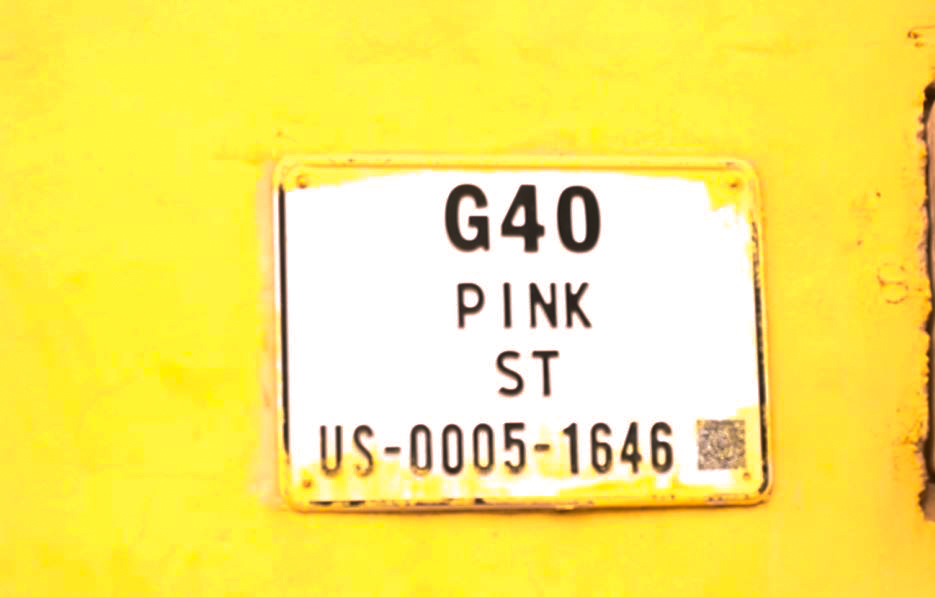
Even more concerning were the unusual street and road names found on the few existing plates. Examples like “Green Road,” “Pink Street,” and even “Dragon Fruit” were observed. The core purpose of an addressing system is easy identification, yet these arbitrary names seem to hinder, rather than help.
Do Residents Understand the “Digital” Landmarks?
To assess the practical utility of these addresses, the Voice of Buluk team engaged with residents living in houses with address plates. The findings were telling: not a single person could pinpoint the exact location of “Green Road,” “Pink Street,” or “Dragon Fruit.” This starkly highlights a disconnect between the assigned digital addresses and the local understanding of the area.
Missed Opportunities: Why Not Use Local Landmarks?
Buluk’s settlement style is characterized by well-known and easily recognizable landmarks. For instance, mentioning “Akinkang” in Fumbisi or “Azantilow” in Sandema immediately provides clear directions, even for a child. These are established points of reference deeply ingrained in the community’s consciousness.
Given this, the Voice of Buluk team raises critical questions for the authorities:
- Where are “Green Road,” “Pink Street,” and “Dragon Fruit” located? If residents cannot identify these “landmarks,” how can the system serve its intended purpose?
- Why are established and easily recognizable local landmarks such as “Akinkang,” “Azantilow,” “Abil Yeri,” and “Awuring Yeri,” or even common local trees and fruits like “Baobab Tree,” “Gaamu,” and “Gong” not being utilized as part of the addressing system?
Optimizing GhanaPostGPS for Local Context
For the GhanaPostGPS to truly succeed in Buluk and similar regions, it’s imperative that the system integrates with local realities. Adopting culturally relevant and easily identifiable landmarks would significantly improve the accuracy and usability of the digital addressing system, ultimately fulfilling its promise of easy identification and location for all.
What are your thoughts on integrating local landmarks into national addressing systems?